The Village of Waterford, Virginia
A National Historic Landmark

|
The Village of Waterford, Virginia |
| |
|
History Gives Us A Preview of the Drought Next TimeBy Patrick J. Michaels
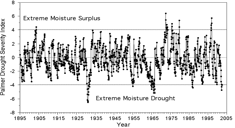
This isn't the storyboard for the next global warming flick. It's a scene from a much more fearful genre: reality. Welcome to the summer of 1930. Judging droughts is a little like judging an ugly contest, a somewhat subjective affair. With that caveat, I'll opine that the current one is very reminiscent of the prolonged moisture shortage that plagued our region and much of the Northeast from 1964 to 1967. And even though Virginia Gov. Mark R. Warner declared a state of emergency on Friday, this drought is nothing compared with what happened in the summer of 1930. That was the peak of a two-year drought that remains the benchmark for this area in the era of modern rainfall measurement, which began in 1895. On a graph charting the Palmer Drought Severity Index, a measure of drought for central Maryland, the 1930 outlier is obvious (See below). Our current misery is one of the low points in a prolonged rainfall deficit that began during the spring of 1998, right after the end of thaSeasonal Streamflow Conditions and Historic Droughts in Virginia
Most of the time, one person's drought can be a mere inconvenience for someone else. A short-term deficit -- merely six summer weeks with little rain -- can devastate crops. Droughts lasting a year, which occur in the Mid-Atlantic when we get about 60 percent of our normal 40 inches of rain, begin to draw down shallow-water wells and dry up livestock ponds. But the most severe droughts, like 1930's, touch everyone in ways that are not immediately obvious. For example, dry ground produces spectacular heat. Normally, our high temperatures (away from the urban cores) cap at around 95 to 98 degrees on a sunny day. That's because it's usually wet around here (the official climate designation for the Mid-Atlantic is "humid subtropical"), and a lot of the sun's energy goes toward the evaporation of water, contributed by the jungle of vegetation that covers our region. In really dry years, like 2002, 1999 or 1930, the soil becomes so arid that trees stop transpiring and the sun finds no water to evaporate. This began in earnest in early August this year, as trees started to shed leaves normally retained until October. When things get this dry, all the sun's energy goes toward heating the surface and rural temperatures bump from the high 90s into the low 100s, usually hot enough to beat daily records lasting a century or so. In fact, most Mid-Atlantic weather stations average only about one 100-degree day per year. Not in 1930. Rural Woodstock, hard in the middle of the Shenandoah Valley, had 21 of them. The high on July 20 was 109, which remains Virginia's official record. Rainfall was virtually nonexistent that summer. Except for a few places that received a lucky thunderstorm, much of the Mid-Atlantic saw less than an inch between June 20 and the end of August, or about 10 percent of normal rainfall. For comparative purposes, the driest regions currently are running around 40 percent of normal for the past three months (not counting last week's beneficial rain). The 1930 horror show reached its peak between July 19 and Aug. 10. Here's the run of that summer's high temperatures recorded at Charlottesville's Leander McCormick Observatory, a rural station on a hilltop covered with thick vegetation. If anything, these figures should have been lower than those in the surrounding areas. Starting on July 19, they were: 103, 107, 106, 105, 97, 92, 102, 104, 98, 103, 106, 90, 95, 91, 97, 101, 106, 102, 90, 100, 99, 105 and 98. The Washingt on Post maintained an accurate thermometer at a downtown newspaper kiosk that didn't have the luxury of being a well-vented "official" site. Shade temperatures reached 107 on July 19, 1930, 109 on July 27 and Aug. 3, and 110 on July 20 and Aug. 9. Thousands of Washingtonians slept in the District's parks. Former Minnesota congressman Charles Davis died of heatstroke. On Aug. 7, The Post headlined a story, "30 Thirsty Snakes Die for Attacking Turkeys." (Farmers reported that the reptiles were after blood.) What would happen if 1930 repeated itself in 2003? Given a drought of similar magnitude and geographical distribution, D.C. would be much hotter. The city is much larger than it was, and airflow is even more impeded. Conservatively estimating, urban core temperatures would probably reach around 113. It is impossible to predict exactly how many deaths would result. If the power stayed on, research by my University of Virginia colleague Robert Davis and myself suggests maybe 50 to 100. But it's not at all clear that the air conditioners would continue to run. A similar, but short-lived, hot blast occurred on July 4 and 5, 1999, again enhanced by very dry conditions. Rural temperatures peaked at 105 degrees. Regional power people have told me they fear that only the Fourth of July holiday prevented a major electrical failure. If it had been a workday, the system would likely have exceeded its previous peak, the frigid morning of Jan. 11, 1994, which was marked by rolling brownouts as people turned up their heat. Soon after the power goes out, deaths begin. We know this from the Chicago heat wave of July 1995, when, a thundershower caused a major outage. About 500 died. Air quality? Some 300,000 acres of Virginia forest firecrackered skyward in 1930, about 30 times the current annual average. Atmospheric chemistry doesn't care whether polluting organic compounds or obnoxious oxides are produced by a burning tree or an aging Belchfire 8. The result is the same: unhealthy air. Low-level ozone, a pulmonary irritant, increases exponentially with temperature. There have been 10 Code Red (unhealthy) and two Code Purple (very unhealthy) air quality days in Virginia in 2002. Prior to this year, we'd had only one Code Purple, in 1999. Mix in 1930's temperatures, add an increasing amount of urban warming and a bit more forest-fire smoke, plus the shimmering conga lines of SUVs panting on Interstates 66 and 395, and we would probably have to invent a new category: Code Black (deadly). Droughts are expensive. After adjusting for inflation, the 1930 drought remains the most costly natural disaster in the modern Virginia record, totaling close to a cool $1 billion. It is noteworthy that the governor has called attention to the current drought as an additional load upon already strapped Virginia finances. The cost of 1930 puts some legendary local events to shame, namely Hurricanes Camille (1969), Agnes (1972) and Floyd (1999). Given our infrastructural changes, including dependence on automobile commuting, which would likely be severely curtailed because of the exponential increase in pollution caused by extreme heat, a repeat of 1930 could easily hit the multibillion-dollar threshold. Which costs more, closing National Airport because of terrorists or closing I-395 because of ozone? In 1930, the James River was a sea of rocks. Water was so hard to come by that thirsty state highway road crews were refused drinking water by nearby residents. I'd like to say that's as bad as the disaster documentary can get here -- fires, incivility, deaths, thirsty snakes and agricultural bankruptcy -- but then there's the Fortress Monroe, Va., precipitation record. Virtually continuous back to 1837 when combined with figures from nearby Norfolk, it is one of only a handful of precipitation records of such quality and length over all of North America. And it provides a perspective that puts even 1930 in the shade. Droughts are defined by a combination of intensity and duration. On the one-year time frame, droughts are considered large when the 12-month rainfall averages about 60 percent of normal. That's been true of the driest periods in our current long-term drought. The driest 12-month periods in the drought that peaked in the summer of 1930 ran approximately 50 percent of normal. That additional 10 percent deficit accrued mainly in the summer and is the difference between this year's misery and 1930's tragedy. On the multi-year time scale, 75 percent of normal rainfall indicates a serious problem, which is what makes the Fortress Monroe record so ominous. The entire period from 1851 to 1855 -- half a decade -- shows the area receiving only 60 percent of its average rainfall of 44 inches per year. For comparative purposes, over the past three drought-prone years, Maryland and Virginia have averaged between 80 percent and 90 percent of normal rainfall. I first stumbled upon the Fortress Monroe record, as well as the better-known 1930 history, soon after I became state climatologist, more than 22 years ago. Since then, through several small-fry droughts and a couple of whoppers, I have made every effort to draw the remarkable Fortress Monroe anomaly to public attention. It is a worst case with unimaginable consequences, a movie I do not want to see, and a contingency for which there has been no preparation. All we can do in the current situation is conserve water where it is needed. Rather than invoke statewide measures, a clear political mistake made in Maryland in 1999 (the drought was not statewide), we now rely more on local authorities and rational geography. On Friday, Warner ordered conservation methods for specific river basins rather than artificially derived political boundaries. These actions are in concert with local restrictions, which tend to be applied conservatively. Local authorities respond to local politics and they surely are loath to impose discomfort when it is not necessary. Whether conservation is mandated or set by market pricing (an increasingly attractive option in many local communities), people soon realize that the SUV with the "Save the Earth" bumper sticker -- that rolling non sequitur common at regional beaches -- doesn't have to be washed every week. Nor do our children require half-hour showers. These measures will help. But I find little comfort in history. If people think conditions are bad now, they need to look first backward, to 1930 and the mid-19th century, and then forward. How will we adapt to the inevitable repetition? Copyright. This article appeared in the Washingto n Post on September 2002. Patrick Michaels is state climatologist for Virginia and author of "The Satanic Gases: Clearing the Air About Global Warming" (Cato Institute).
x |
|
|
- 11/20/2004 |