The History of Loudoun County, Virginia
Part of the Waterford village web site

|
The History of Loudoun County, Virginia |
|
|
|
|
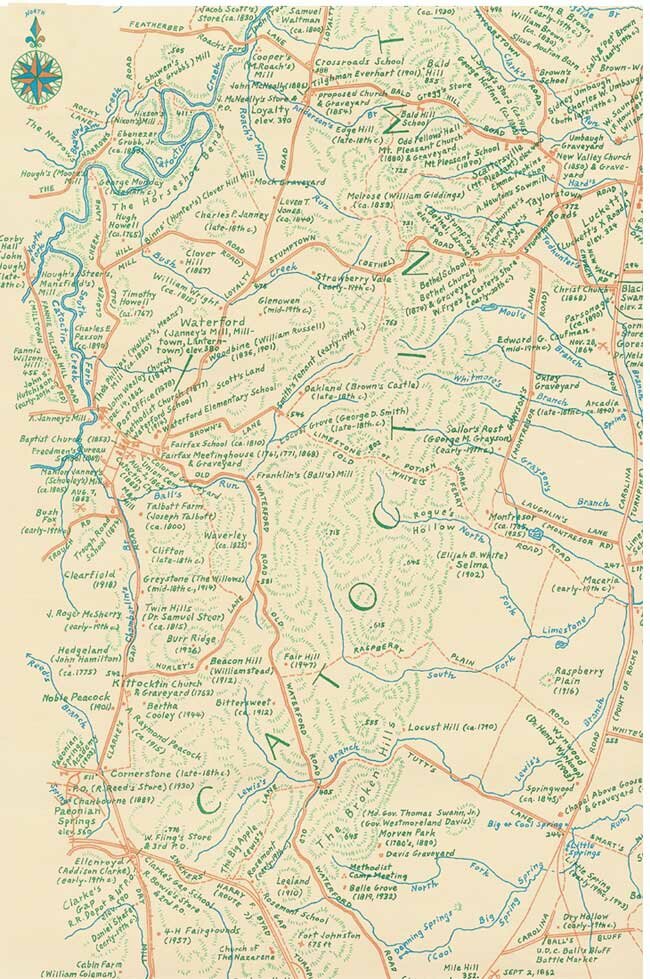
Historical Maps and Publications by Eugene ScheelThe Virginia Historical Society has called Gene a modern-day Jed Hotchkiss – the Civil War map-maker – because his maps are so detailed and are drawn by hand. Gene is a historian and mapmaker with offices in Waterford, Loudoun County Virginia. He is the author of 9 books on Virginia History, and provider of over 50 historical maps covering Virginia, other states and foreign nations.
Gene Scheel's work has been featured in numerous journals, magazines, and newspapers. The Washington Post notes "his hand-drawn works of cartographic art are treasured as pictures of history." How to orderAll maps and books may be autographed, if desired. Please add $4 for mailing one map, $5 for more than one map up to any number. Please add $3.20 for mailing one book, $4 for more than one book. Maps are sent in priority mailing tubes. Order directly from: Maps
|
|||||||||||||||||||||||
 |
|
Click to enlarge |
All maps are of Virginia, unless noted. All county maps cover from a mile to two miles into the adjacent counties.
Gene's maps usually have about twenty times the name detail of the 1:24,000 U. S. Geological Survey maps. They are carefully field checked, by auto and by foot, and correct many spelling and location errors on government maps. Historic names are noted as well as present names.
All maps are in color except if noted; most show all Civil War battles, actions, skirmishes, etc.; family graveyards, old roads, trails, stores, post offices, mills, American Indian villages, fish traps--always differentiating between what's standing today and what was once there.
Clarke County (1982), 19" by 23". $12, only a few left
Curlpaper County in 1776 (1975), 18" by 22". Includes present Madison and Rappahannock Counties. $25, only a few left
Culpeper County, with detailed insets of towns and villages (1975), 3' by 4'. $12 (out of print; a few copies are shop-worn, some spots); $8 folded edition.
Fauquier County in 1776 (1975), 18" by 22". $20, only a few left
Fauquier County, with detailed insets of towns (1996), 3' by 4'. $25, only a few left
Frederick County and Winchester, with detailed insets of towns (1974), 3' by 4'. $12
Loudoun County, with detailed insets of towns (1990), 3' by 4'. $12; folded ed. $8
Loudoun County (1975), 18" by 24". This is a small map of Loudoun. $10
Madison County (1983). $10
Medley District, Montgomery County, Maryland, 15" by 22". Partial redrawing (blue color added) of western Montgomery County on Potomac River (Poolesville, Monocacy, Barnesville, Boyds, Dawsonville areas). $4
Middletown & The Cedar Creek Battlefield (1996), 21" by 27". Drawn for the town's 200th anniversary. Shows all pre-1950 houses with dates, builders, owners. $15, only a few left
Mosby's Confederacy (1995), 12" by 18". Shows area of Mosby's June, 1864, order, where men should stay. Black and white. $5, only a few left
Mosby - John Singleton Mosby Heritage Area (1996), 33" by 33". Parts of Loudoun, Fauquier, Warren, Clarke, Jefferson, and Prince William Counties. $25 (artist's proof on heavier stock, $50). Only a few left.
Orange County and Middleburg Hunts and Piedmont Foxhounds (1978), 18" by 23". Companion to the Virginia Hunt Country Map. $20, only a few left
Potomac River (1995), 22" by 30". From Brunswick, down river to VanDeventer's I. Includes areas about Leesburg, Waterford, Taylorstown, Point of Rocks, Dickerson, Poolesville, Suglarloaf Mtn. Shows pre-1950 houses and dates, much river detail including Indian fish traps, Civil War crossings, best fishing spots. $12
Prince William County: African-American Heritage. About 20" by 26", color. $10
Prince William County & Manassas Battlefields (1992), 30" by 40". Very detailed insets of the 1861, 1862 battles. $12, only a few left (folded ed. comes with book – see below).
Rappahannock County (1999), 27" by 31", also shows more than 300 pre-history houses and past owners. $15
Snickersville Turnpike, Loudoun County (1997), 3' by 1'. Shows pre-1950 houses, owners, and building dates. $25 (Artist's proof edition on heavier stock, $50)
Snickersville Turnpike - Original Land Grants Along and Adjacent to Snickersville Tpke. (1997), a companion map to the above, black and white, 2' by 10". $5
Stafford County (2003) $15
Tri-Counties of Upper Prince William, East Fauquier, and Lower Loudoun (1994), 18" by 23". Includes areas of Middleburg, Aldie, Haymarket, Manassas Battlefields. $10
Virginia Hunt Country (1985, rev. ed.), 18" by 23". Covers hunts north from Culpeper & Madison to Potomac River. $20, only a few left
Warren County (2004)
Washington-Dulles International Airport (1982), 31" by 33". Prepared for the airport's 20th anniversary. Shows areas from Leesburg east to western Fairfax, and south to Manassas. This map named the airport. $10
Not my maps, but excellent rare reproductions in full color of Union Lt. William H. Willcox of Gettysburg and Antietam Battlefields, drawn after the battles in 1863. The Antietam Map is inscribed: "Obtained from Washington and Presented to Gen. Robert E. Lee by J. E. B. Stuart." Both are 17" by 19", on acid-free paper. $20 each, both cost $35. These maps are among the finest of Civil War renderings.
Crossroads and Corners - The Villages, Towns, and Post Offices of Prince William County - Past and Present (1996). Comes with the folded map of Prince William County. $17
Culpeper: A Virginia County's History (1982), 500 pp. The County's only complete history - to year 1920. $40
The Civil War in Fauquier, 3rd edition, comes with a 3' by 4' map of Fauquier (folded). $22
Loudoun Discovered - Communities, Corners & Crossroads. A series of five volumes (2003), approximately 900 pages plus folded and flat map of Loudoun County. The history of the 120-or-so towns, villages, and communities in Loudoun County. $100 plus $10 for shipping. Volumesare available individually.
![]()
eugene m scheel, gene scheel, eugene scheel, books, publications, maps, Fauquier county, map, prince william county, culpeper county, culpepper, warren County, snickersville turnpike, rappahannock county, potomac river, john mosby, civil war, african americans, clarke county, maps, loudoun county, civil war towns, villages village, national historic landmark

|
- 06/03/2004 |
